Module · GPS
Gestion POI
Gestion POI
Introduction
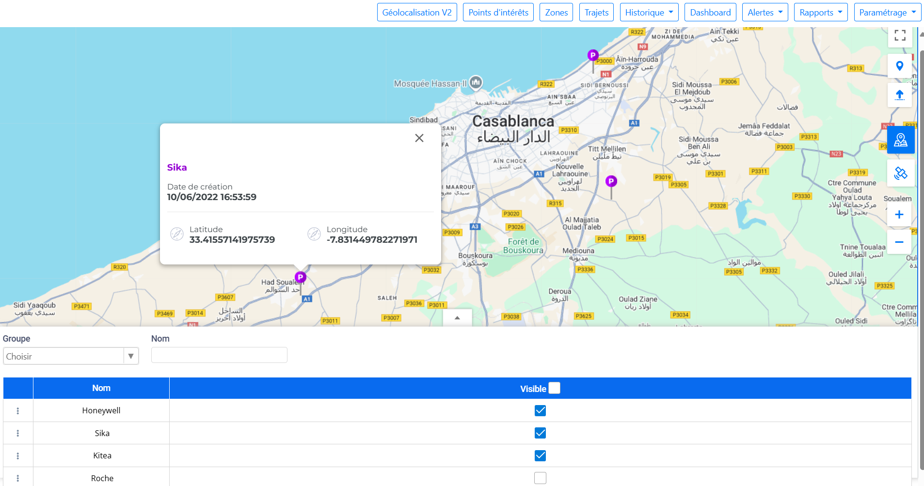
L'interface "Points d'intérêt" (POI) est un espace dédié à la gestion des emplacements stratégiques sur la carte. Elle offre une présentation claire et intuitive qui permet de visualiser et de manipuler facilement les différents points d'intérêt. L'interface affiche les POI sous forme de repères visuels sur la carte, personnalisables avec des noms, des couleurs et des icônes distinctives, offrant ainsi une vue organisée des zones d'importance pour l'utilisateur.
Chaque POI est représenté graphiquement sur la carte pour une identification rapide, et des fenêtres d'information contextuelle peuvent être ouvertes pour accéder aux détails des emplacements. L'interface permet une gestion fluide des points d'intérêt, avec un accès facile à leurs paramètres pour modifier ou supprimer des emplacements au besoin. Elle s'intègre naturellement dans l'écosystème de gestion géolocalisée de la plateforme, offrant une vue globale des points critiques pour l'utilisateur.
Ajout de Points d'Intérêt
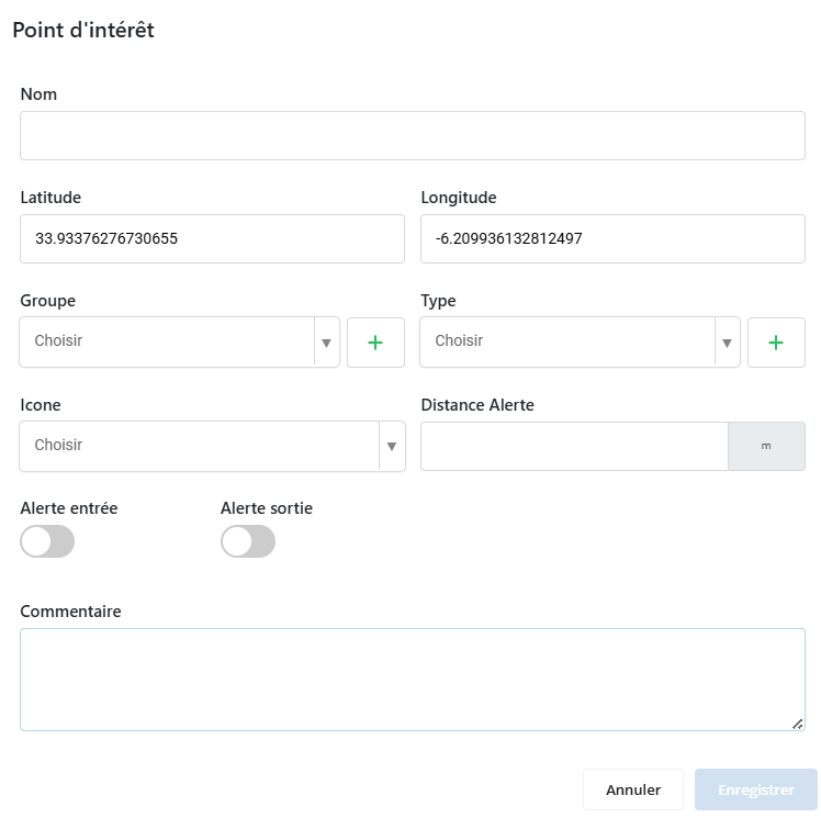
Lorsque vous cliquez sur un emplacement de la carte dans l'interface des points d'intérêt (POI), unpopups'affiche, vous permettant de créer et de personnaliser un nouveau POI avec un formulaire détaillé.
Détails du Popup d'Ajout de POI
-
Nom: Saisissez le nom du POI pour une identification unique.
-
Groupe: Choisissez un groupe pour le POI. Les groupes sont définis par l'utilisateur pour organiser les POI de manière structurée.
-
Type: Sélectionnez le type du POI. Les types sont personnalisables pour mieux classifier les POI selon leur nature.
-
Icône: Personnalisez le POI en choisissant une icône qui le représentera visuellement sur la carte.
-
Distance d'Alerte: Définissez une distance (en mètres) autour du POI, qui conditionne à quel point les véhicules doivent se rapprocher pour que leur passage soit enregistré.
-
Alertes de Passage: Configurez l'enregistrement des passages par le POI. Les alertes sont enregistrées dans un rapport appelé"rapport passage par POI". Vous pouvez activer :
- Alerte d'Entrée: Enregistrez lorsqu'un véhicule entre dans la zone autour du POI.
- Alerte de Sortie: Enregistrez lorsqu'un véhicule quitte cette zone.
- Les Deux: Enregistrez les deux types de passage.
-
Temps Dépassé: Digiparc calcule automatiquement le temps que chaque véhicule a passé à proximité du POI en soustrayant le temps de départ du temps d'arrivée.
-
Commentaires: Ajoutez des commentaires pour expliquer l'objectif du POI ou pour laisser des notes aux autres utilisateurs.
Plein écran
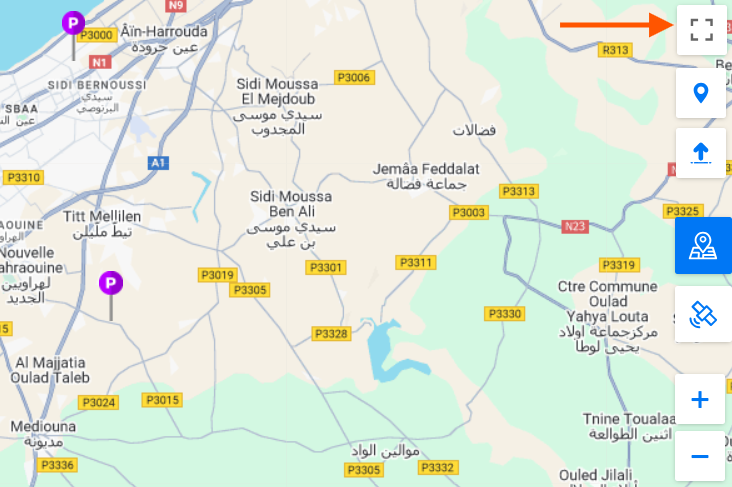
La fonctionnalité "Plein écran" dans l'interface "Points d'intérêt" permet d'agrandir l'affichage de la carte à 100% de l'espace disponible sur l'écran. Cette option est particulièrement utile pour avoir une vue complète et détaillée des points d'intérêt sans être gêné par les autres éléments de l'interface. En activant le mode plein écran, l'utilisateur peut naviguer plus aisément entre les différents POI, tout en profitant d'une expérience de visualisation immersive et optimisée pour une meilleure gestion des emplacements.
Affichage de zone
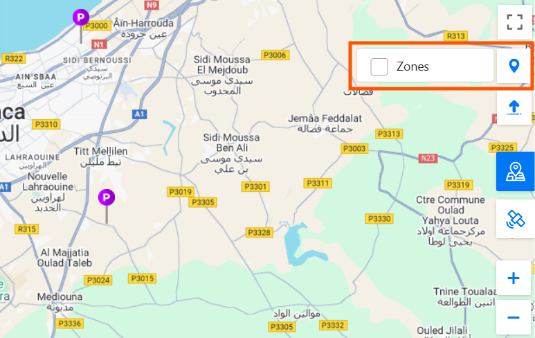
La fonctionnalité "Affichage de zone" dans l'interface "Points d'intérêt" permet de gérer la visibilité des zones déjà tracées dans l'interface dédiée aux zones. Cette option donne à l'utilisateur la possibilité d'afficher ou de masquer ces zones en fonction des besoins de navigation. En activant cette fonctionnalité, les zones préalablement définies apparaissent sur la carte aux côtés des points d'intérêt, offrant ainsi une vue combinée des zones d'opération et des POI. Si nécessaire, les zones peuvent être masquées pour obtenir une vue plus claire et dégagée des seuls points d'intérêt.
Importation et Exportation en masse
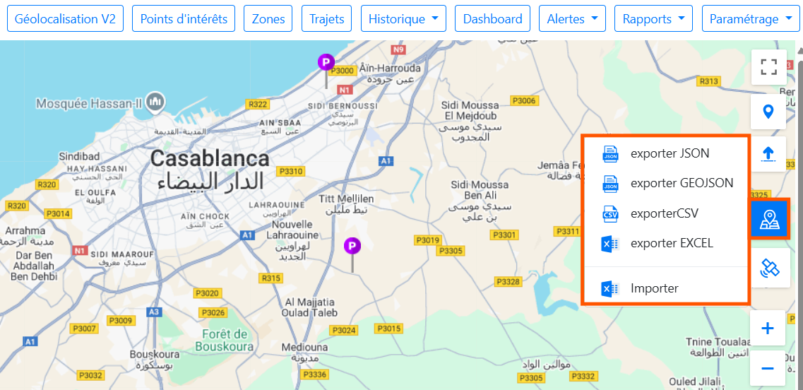
La fonctionnalité d'importation et d'exportation en masse des points d'intérêt dans l'interface "Points d'intérêt" de Digiparc est un outil puissant conçu pour faciliter la gestion efficace des données géolocalisées. Elle permet aux utilisateurs de gérer rapidement un grand nombre de points d'intérêt (POI) en offrant des options flexibles pour l'exportation et l'importation des données.
Exportation en masse
Cette fonctionnalité vous permet d'exporter les points d'intérêt créés sur Digiparc dans plusieurs formats de fichier, adaptés à différents besoins de traitement ou de partage des données :
- Excel: Idéal pour les rapports et l’analyse, ce format vous permet d’organiser les POI dans une feuille de calcul claire, avec des colonnes dédiées à chaque attribut du POI, comme le nom, les coordonnées, le type, etc.
- JSON et GeoJSON: Ces formats sont utiles pour les échanges de données entre systèmes et applications. LeJSONest particulièrement apprécié pour son format structuré qui facilite l'intégration dans des outils de développement, tandis que leGeoJSONest spécialement conçu pour les données géospatiales, utile pour les applications de cartographie.
- CSV: Ce format léger et lisible est largement utilisé pour les échanges de données, permettant une intégration facile avec divers outils d’analyse ou de gestion.
Importation en masse
En plus de l'exportation, Digiparc permet l'importation en masse des points d'intérêt à partir de fichiersExcel. Cette fonctionnalité est conçue pour simplifier l'ajout de nombreux POI à la fois, évitant ainsi la saisie manuelle de chaque point d'intérêt individuellement.
Lors de l'importation, vous devez suivre uncanevas prédéfiniqui précise les champs requis pour chaque POI, tels que le nom, les coordonnées géographiques (latitude et longitude), la catégorie, et d'autres attributs pertinents. En respectant ce format, vous garantissez que les données sont correctement importées et intégrées dans l'application sans erreurs.
Mode satellite
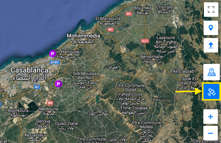
La fonctionnalité de changement de l'affichage de la carte permet aux utilisateurs de basculer entre différents modes de visualisation de la carte pour répondre à leurs besoins spécifiques. En particulier, cette fonctionnalité permet de passer en modesatellite.
Le mode satellite offre une vue détaillée et réaliste de la carte en affichant des images aériennes capturées par satellite. Ce mode fournit une représentation visuelle précise du terrain, des bâtiments, et d'autres caractéristiques géographiques, offrant ainsi une perspective enrichie par rapport à la vue cartographique traditionnelle.
Zoom
La fonctionnalité de zoom permet d'ajuster la vue de la carte pour obtenir plus de détails ou une vue plus large. Vous pouvez effectuer le zoom de deux manières :
- Zoom avant et arrière :Utilisez les boutons+pour agrandir la carte et-pour la réduire, permettant un ajustement précis du niveau de détail.
- Geste de la souris :Faites défiler la molette vers l'avant pour zoomer et vers l'arrière pour dézoomer, offrant une manipulation fluide et rapide.
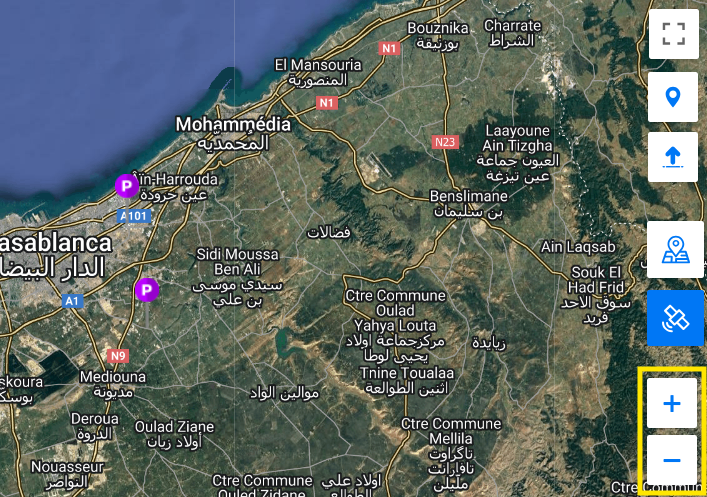
Tableau de manipulation des points d'intérêt
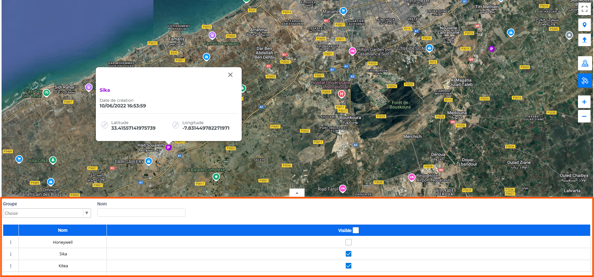
Le tableau de manipulation des points d'intérêt fournit une vue structurée et interactive des POI, facilitant leur gestion au sein de l'interface. Ce tableau comprend plusieurs éléments clés pour une manipulation efficace des points d'intérêt :
Composants du Tableau
-
Dropdown des Groupes de POI: Situé en haut à gauche du tableau, ce menu déroulant vous permet de sélectionner et d'afficher les POI selon différents groupes définis. Cela permet de filtrer les points d'intérêt pour une gestion plus ciblée.
-
Case de Recherche par Nom: À côté du dropdown, une case de recherche permet de trouver rapidement un POI en saisissant son nom. Cela facilite l'accès aux points d'intérêt spécifiques sans avoir à parcourir l'ensemble du tableau.
-
Options de Menu (Trois Points): Pour chaque enregistrement de POI dans le tableau, un menu à trois points propose deux options :
- Modifier: Permet de mettre à jour les détails du POI et ses attributs.
- Supprimer: Offre la possibilité de supprimer le POI du tableau.
-
Colonnes d'Affichage:
-
Nom du POI: La colonne affiche le nom du POI sous forme de lien cliquable. Cliquer sur ce nom vous conduit directement au point sur la carte pour une visualisation rapide et une gestion contextuelle.
-
Checkbox de Visibilité: Cette colonne contient des cases à cocher permettant de gérer la visibilité des POI. Vous pouvez choisir d'afficher ou de masquer individuellement chaque POI ou de le faire en masse pour une gestion plus efficace.
-
Avantages
- Filtrage et Recherche Faciles: Le dropdown et la case de recherche permettent de naviguer rapidement parmi les POI.
- Gestion Contextuelle: Les options de menu et les liens cliquables facilitent la modification et la visualisation directe des POI sur la carte.
- Contrôle de Visibilité: Les checkboxes offrent une gestion flexible et personnalisable de la visibilité des POI.
Ce tableau est conçu pour simplifier la gestion des points d'intérêt, rendant leur manipulation plus intuitive et efficace.