Module · GPS
Live Vehicle Tracking
Live Vehicle Tracking
Introduction
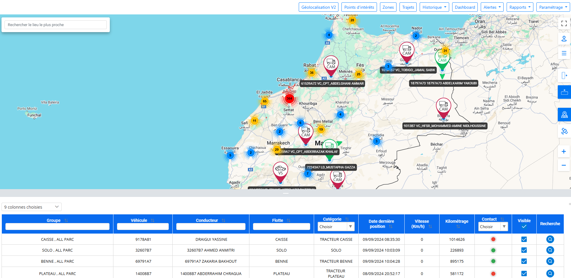
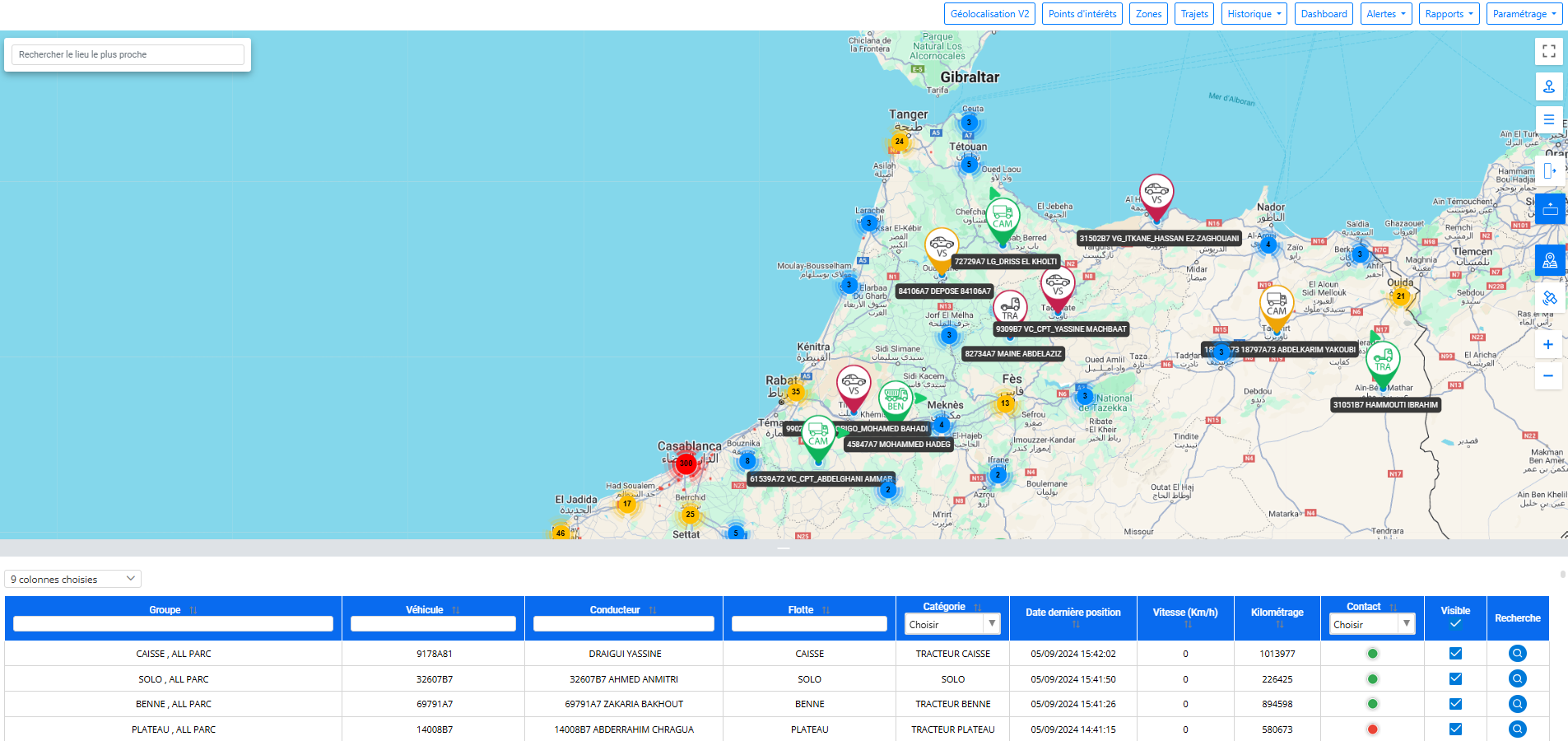
Geolocation is an interface dedicated to the visualization and tracking of vehicles in real time. It allows you to know the instantaneous position, the status of the vehicle as well as information such as mileage, speed, fuel level, and whether the engine is running or stopped. Many practical features make its use simple and fluid, such as searching by address or coordinates, immediately extracting vehicle coordinates, adding points of interest or tracing areas. An informative table located at the bottom of the screen displays the different attributes of the vehicle.
Address search
The address search functionality on our platform allows you to quickly and easily locate a location by simply entering the address you are looking for. Thanks to our intelligent suggestion system, suggested addresses are automatically presented to you as you type. This saves you time and reduces potential errors in finding locations. Whether you're looking for a specific address or only have a partial starting point, our tool is designed to give you a smooth and optimized search experience.
This feature is ideal for users who need fast and accurate navigation, whether managing fleets, planning routes, or locating specific points of interest.
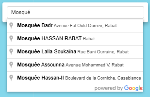
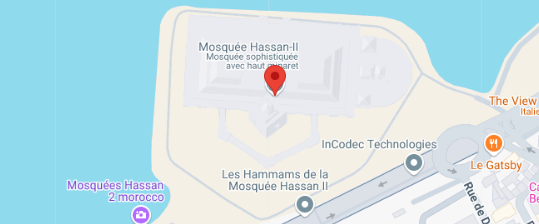
When you select an address from the suggestion list, the map automatically centers on the corresponding location. A marker is precisely placed on the selected point, allowing the location to be clearly visualized on the map. Additionally, auto zoom is applied to provide a suitable level of detail, so you can quickly scope out the surroundings and navigate around the location. This feature provides a smooth and interactive user experience, making it easier to manage locations and optimize field movement.
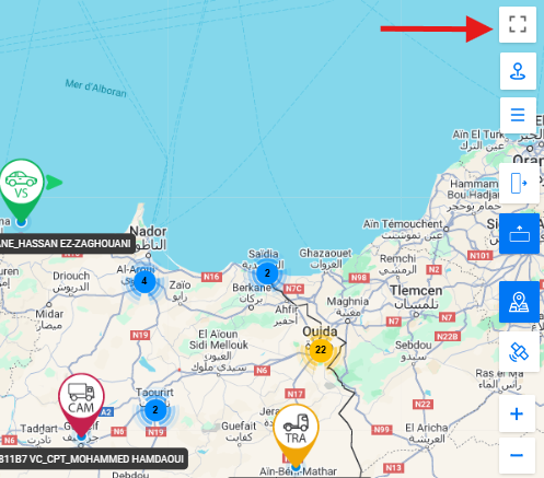
Fullscreen
This feature allows you to maximize the map display by making it full screen with 100% zoom. By activating this option, the map takes up the entire surface of your screen, providing a clear and detailed view of the selected location. This facilitates better viewing of fine details and allows you to fully concentrate on analyzing the location without distractions. You can explore your surroundings and plan your routes with greater precision, while benefiting from an immersive user experience.
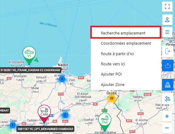
Location search
The search by coordinates functionality allows you to locate a specific point on the map by directly entering its geographic coordinates (latitude and longitude). By entering this information, the map automatically positions itself on the exact point corresponding to the coordinates provided. This feature is particularly useful for precise location tracking when a complete address is not available or when it is necessary to find specific locations using exact geographic data. By visualizing the location with a distinct marker, you can easily analyze the area around that point and integrate this information into your planning and management operations.
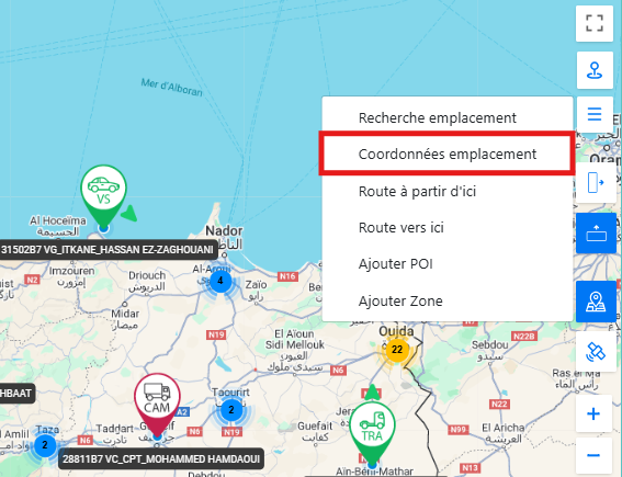
Location coordinates
The location coordinate generation feature allows you to get the precise geographic coordinates (latitude and longitude) of a point by simply clicking on any location on the map. When a point is selected, the corresponding coordinates are instantly displayed, giving you a quick and convenient method to identify the coordinates of specific locations. This feature is ideal for users who need to determine accurate geographic data for planning, mapping, or integration into other systems. By making it easy to extract geographic information directly from the map, this option optimizes your workflow and improves data accuracy.
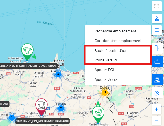
Route from here/to here
The Route From Here/To Here feature simplifies the route planning process by allowing you to easily plot the route between two locations on the map. With a simple click on the starting point and the ending point, the application automatically calculates and displays the most efficient route between these two points. This feature is particularly useful for quickly obtaining directions, optimizing routes or planning trips. This allows you to view the entire route, including roads and intersections, while having a clear view of the different stages of the route. This option improves efficiency and accuracy in route management and field navigation.
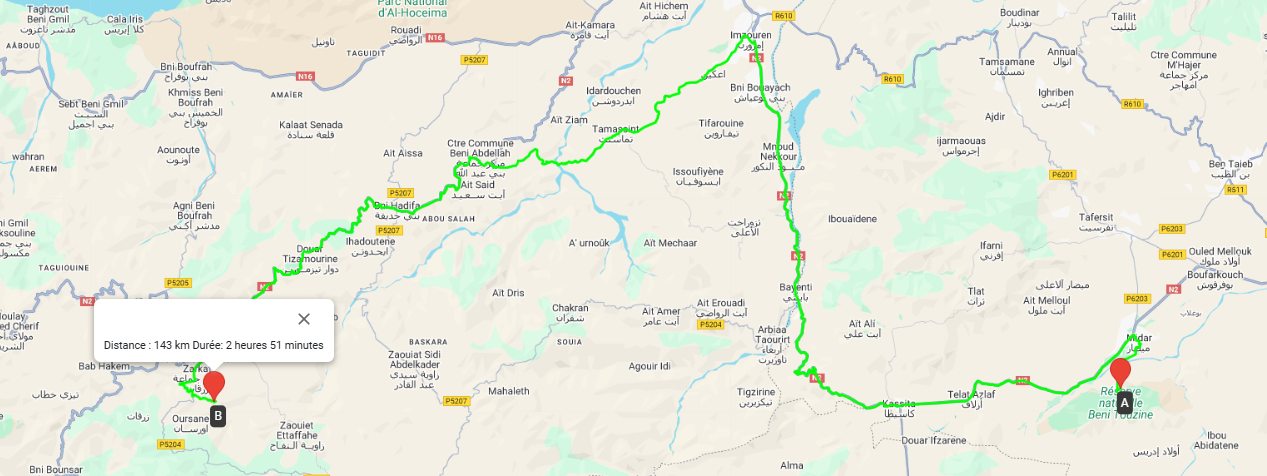
In addition to visualizing the route, this feature also generates key information such as total distance and estimated trip duration. This data helps you quickly assess the time and resources needed to complete the trip, improving travel management and decision-making. Whether you are planning trips for appointments or for logistics operations, this option gives you a complete and detailed view of your route.
Adding points of interest
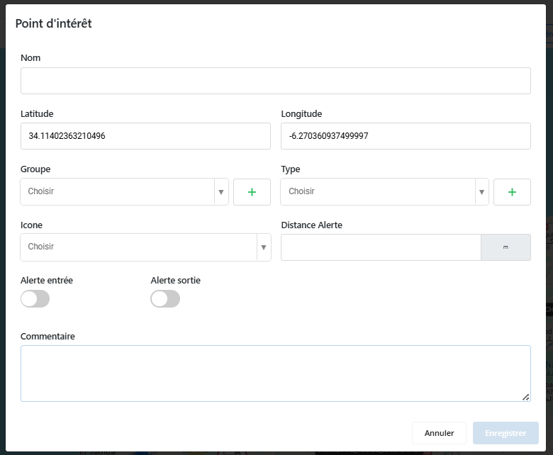
The Add Points of Interest feature allows you to save specific locations on the map for later management and reference. By creating a point of interest, you can give it a distinctive name, a representative logo and a category type to better organize and classify it according to your needs.
This functionality also offers the possibility of assigning vehicles to each point of interest. You can configure alert conditions to receive notifications when vehicles arrive at or leave the point of interest. Additionally, you have the ability to customize the distance from which these alerts are triggered, allowing you to set precise thresholds for notifications based on your operational requirements. This option is ideal for tracking vehicle movements, optimizing routes and improving the management of important sites.
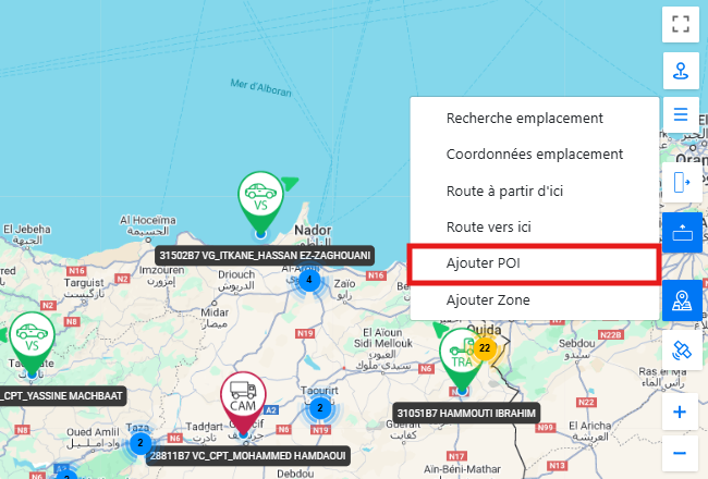
To save a point of interest, simply click on the desired location on the map. A pop-up window will then appear, allowing you to enter the relevant information for this point.
In this window, you can enter a distinctive name for the point of interest, select a logo to represent it visually, and choose a category type to organize it efficiently. You also have the ability to assign vehicles to the point of interest and define alert conditions, including the distance from which alerts are triggered. Once all the information is entered and the settings are configured, you can save the point of interest to track it and manage notifications related to this location.
This feature makes it easy to manage important sites, organize geographic information, and track vehicles, while providing an intuitive interface for quick and accurate setup.
Adding Zones
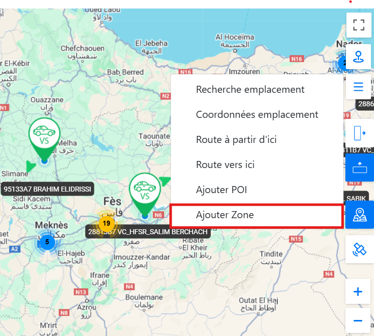
The Add Areas feature allows you to plot custom areas directly on the map in real time. You can create a zone by demarcating a specific region, which can be used to monitor and manage specific vehicles. Each area can be personalized by giving it a unique name and a distinct color, making it easier to visually identify on the map.
In addition to visual customization, each zone has advanced settings for speed management and alerts. You can set a maximum speed limit not to be exceeded inside the zone. In addition, you have the possibility to configure alerts for each entry and exit of vehicles in this area. These alerts, as well as other conditions, can be adjusted not only when creating the zone, but also during subsequent modifications.
These settings only apply to selected vehicles, allowing you to dedicate an area to monitoring specific vehicles or employees. This provides precise control and flexible management for each group of vehicles, improving operational supervision according to the needs of your fleet.
Changing the map view
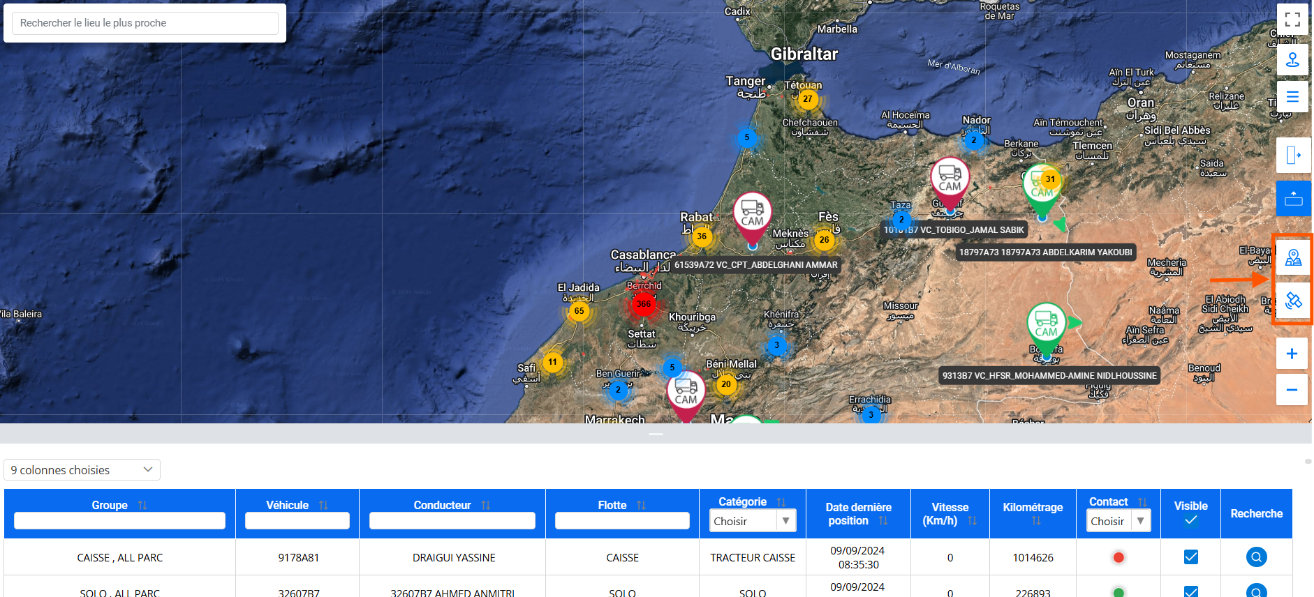
The view switching functionality gives you the flexibility to adapt the map view according to your preferences. You can switch between several display modes, including satellite mode, which provides a real, detailed view of locations, and classic map mode, which displays a more schematic and simplified version.
Satellite mode is ideal for realistic visualization of terrain, buildings, roads and other geographic features. It is particularly useful for in-depth analysis of the immediate environment. The map mode, for its part, highlights clearer and stylized cartographic elements, making navigation and route planning easier.
This feature therefore allows you to personalize your experience according to your specific needs, whether for geographic precision or for better readability of information on the map.
Zoom on the map
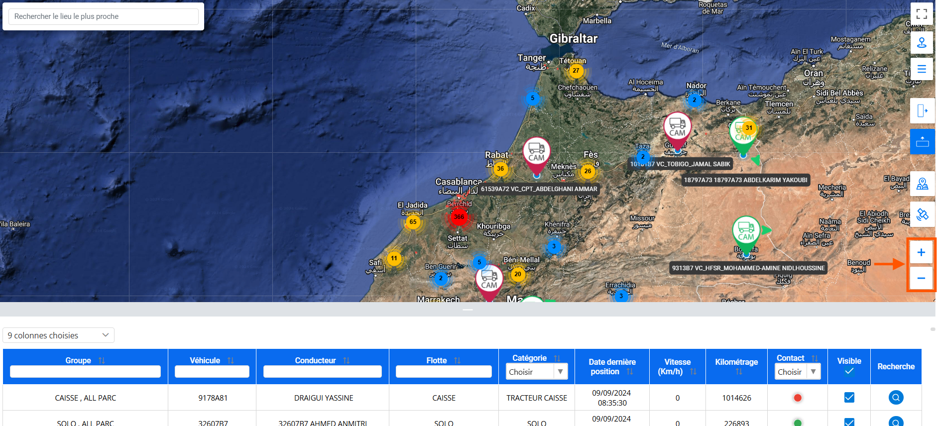
The zoom functionality allows you to easily adjust the scale of the map by clicking the "+" and "-" buttons located on the interface. By clicking the "+" button, you can enlarge the map to get a more detailed view of a specific area, ideal for analyzing precise locations or closely observing vehicle movements. Conversely, the "-" button narrows the view, providing a wider perspective, which is useful for having an overview of the geographical area or for monitoring a larger area.
This manual zoom control ensures a smooth and intuitive user experience, allowing you to easily navigate between levels of detail according to your operational needs.
Navigation table and data management
The navigation table below allows you to view and navigate through your vehicle data in a tabular manner. This table is designed to provide maximum flexibility in information management through advanced customization options.
At the top left of the table, a dropdown menu allows you to select the columns you want to display. You can check or uncheck columns according to your specific needs, making the data display dynamic and tailored to your preferences.
Here is a detailed explanation of the different columns available:
- Group column:This column groups together the vehicles selected by the user to facilitate their management. Each group contains a set of vehicles defined in advance, which simplifies their handling and location within the table.
- Vehicle Column:This column lists vehicle registrations. Each registration is clickable, allowing you to instantly locate the corresponding vehicle on the map when selected.
- Driver Column:You can also search for a vehicle by the driver's name. Records in this column are interactive, allowing you to click on the driver's name to view the associated vehicle directly on the map.
- Fleet Column:This column allows you to categorize your vehicles by fleet. Fleets are created based on vehicle categories (e.g. trucks, light cars, etc.) and can then be used as a filter in the map interface for more targeted navigation.
- Category Column:This information, entered by the user, makes it possible to differentiate vehicles within a fleet. Each category is defined according to the user's specific needs, providing a way to personalize and structure the display.
- Last Position Date:This column shows the last date and time each vehicle was active, providing you with a clear view of which vehicles are running or inactive.
- Instantaneous Speed:Here you can view the real-time speed of vehicles to better monitor their behavior on the road.
- Mileage:This column displays the vehicles' total mileage, allowing you to track their usage and analyze their performance over long distances.
- Contact (Motor):This column informs you whether the vehicle engine is running or off, allowing you to monitor vehicle activity status in real time.
- Visible column (Check-box):Each row has a checkbox that allows you to hide or show selected vehicles on the map. This facilitates more precise and clear management by only visualizing relevant vehicles.
- Magnifying Glass (Historical Research):The last column has a magnifying glass button that serves as a shortcut. By clicking on it, you can directly access the history of a particular vehicle in the search interface.
This table is a powerful tool for optimizing your fleet management, giving you a clear and interactive overview of the data. Thanks to its customizable filtering and display features, it allows you to make informed decisions and easily navigate between different information.