Module · GPS
Zones Géographiques
Zones Géographiques
Introduction
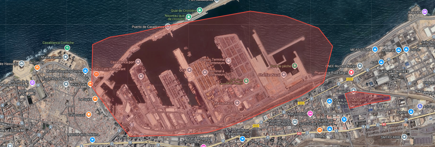
L'interface "Zones" est une fonctionnalité clé qui permet aux utilisateurs de créer, modifier et gérer efficacement les zones au sein de l'application. Cette interface offre une large gamme de fonctionnalités pour la personnalisation et la surveillance des zones, en mettant l'accent sur la flexibilité et la précision dans la gestion des données géospatiales.
Fonctionnalités Principales
-
Création et Modification des Zones: Vous pouvez créer de nouvelles zones ou modifier des zones existantes selon vos besoins. Chaque zone peut être définie par divers attributs, tels que le nom, le groupe auquel elle appartient et la couleur de la zone pour une identification visuelle facile.
-
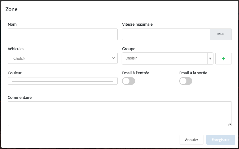
Attributs des Zones: Chaque zone peut comporter plusieurs attributs personnalisables :
- Nom: Identifie la zone de manière unique.
- Groupe: Catégorise les zones en groupes pour une gestion plus structurée.
- Couleur: Permet de choisir une couleur pour une meilleure visualisation sur la carte.
-
Données de Surveillance des Véhicules: L'interface permet de configurer des données spécifiques pour la surveillance des véhicules dans chaque zone :
- Vitesse Maximale: Définissez une vitesse maximale à ne pas dépasser pour les véhicules entrant ou se déplaçant dans la zone. Cette condition permet de suivre et de gérer la vitesse des véhicules pour assurer la conformité aux limites définies.
- Alertes par Email: Configurez des alertes par email pour notifier les responsables dès qu'un véhicule entre dans ou sort de la zone. Cela permet une surveillance immédiate et réactive des événements importants.
-
Application des Conditions: Les conditions de vitesse et les alertes sont applicables selon le choix des véhicules sélectionnés. Vous pouvez spécifier quels véhicules doivent être surveillés selon les critères définis pour chaque zone.
Création et Modification des Zones
La fonctionnalitéCréation et Modification des Zonesvous permet de définir des zones géographiques précises directement sur la carte de Digiparc. Cette fonctionnalité est essentielle pour la gestion et la surveillance des zones d'activité, de sécurité ou de contrôle au sein de votre flotte.
Dessin des Frontières des Zones
Dans la carte, vous pouvezdessiner manuellement les frontières de chaque zone. Grâce à des outils intuitifs, vous avez la possibilité de tracer les limites exactes de la zone selon vos besoins, en dessinant des formes libres ou en suivant des tracés spécifiques. Cela vous permet de définir avec précision l'étendue géographique de la zone, qu'elle soit petite et localisée ou qu'elle couvre une large surface.
Personnalisation des Zones
Une fois les frontières tracées, chaque zone peut être entièrement personnalisée en fonction de ses caractéristiques spécifiques :
- Nom de la Zone: Donnez un nom unique à la zone pour la reconnaître facilement dans l'interface.
- Couleur: Choisissez une couleur distincte pour la zone afin qu'elle soit clairement visible sur la carte.
- Groupe: Assignez la zone à un groupe pour faciliter l'organisation des différentes zones.
Gestion des Alertes et des Conditions
Lors de la création ou modification d'une zone, vous pouvez aussi définir desconditions liées à la surveillance des véhiculesdans cette zone :
- Limite de Vitesse: Imposer une vitesse maximale pour les véhicules qui se déplacent à l'intérieur de la zone.
- Alertes d'Entrée et de Sortie: Configurez des alertes pour être informé lorsque des véhicules entrent ou sortent de la zone.
Ces conditions sont appliquées aux véhicules sélectionnés, vous permettant de suivre uniquement les véhicules d'intérêt dans la zone concernée.
Modification des Zones
Une fois la zone créée, elle peut être modifiée à tout moment. Vous pouvez redessiner ses frontières, changer son nom, sa couleur ou ajuster les conditions de surveillance en fonction des besoins évolutifs de l'opération.
Avantages
- Précision dans le Traçage: La possibilité de dessiner manuellement les frontières des zones garantit une couverture géographique précise.
- Flexibilité et Contrôle: Vous avez un contrôle total sur la création et la modification des zones, permettant une gestion personnalisée des opérations.
- Surveillance Efficace: Les alertes et les conditions appliquées aux véhicules dans les zones garantissent une surveillance rigoureuse.
Surveillance des Véhicules
L'interface de gestion des zones permet de configurer des paramètres spécifiques pour surveiller les véhicules qui se déplacent dans ces zones. Ces données de surveillance sont essentielles pour assurer la conformité, la sécurité, et la réactivité des opérations.
Vitesse Maximale
Une des données clés que vous pouvez configurer est lavitesse maximaleà ne pas dépasser pour les véhicules dans chaque zone :
- Définition de la Limite: Vous pouvez définir une vitesse maximale précise pour chaque zone, en fonction des exigences spécifiques de l'environnement (par exemple, une zone résidentielle ou une zone de chantier).
- Surveillance de la Vitesse: Une fois la limite configurée, l'interface surveille en temps réel la vitesse des véhicules entrant ou circulant dans la zone. Toute violation de la vitesse maximale peut être enregistrée et signalée, permettant ainsi de suivre la conformité des véhicules aux restrictions.
- Gestion et Sécurité: Ce paramètre garantit que les conducteurs respectent les limitations de vitesse, contribuant ainsi à la sécurité des opérations, à la protection des biens, et à la prévention des incidents.
Alertes par Email
L'interface permet également de configurer desalertes par emailpour une surveillance en temps réel des événements liés aux véhicules dans chaque zone :
- Notifications d'Entrée et de Sortie: Vous pouvez configurer des notifications qui seront envoyées par email aux responsables dès qu'un véhicule entre dans ou sort de la zone. Cela assure unesurveillance réactive, permettant aux gestionnaires d’être immédiatement informés des mouvements importants.
- Réactivité et Gestion Instantanée: Les alertes par email sont idéales pour réagir rapidement aux situations critiques, telles que l'entrée d'un véhicule non autorisé dans une zone restreinte ou la sortie imprévue d'un véhicule d'une zone de sécurité.
- Personnalisation des Recipients: Les alertes peuvent être envoyées à des personnes spécifiques, en fonction de leurs responsabilités dans la gestion des zones et de la flotte.
Avantages
- Conformité et Sécurité: La surveillance des limites de vitesse assure que les véhicules respectent les règles, réduisant ainsi les risques d'accidents ou de non-conformité.
- Surveillance en Temps Réel: Les alertes par email garantissent une gestion proactive et permettent une réactivité immédiate face à des événements critiques.
- Personnalisation Totale: Vous pouvez ajuster ces paramètres en fonction des besoins spécifiques de chaque zone, offrant ainsi une flexibilité maximale dans la gestion des opérations.
Application des Conditions
La fonctionnalitéApplication des Conditionsvous permet de définir des règles spécifiques pour la surveillance des véhicules dans les zones, en appliquant les critères de vitesse et les alertes uniquement aux véhicules sélectionnés. Cette personnalisation garantit une gestion ciblée et efficace de votre flotte.
Sélection des Véhicules Concernés
Vous avez la possibilité de sélectionner précisément les véhicules qui doivent être surveillés dans chaque zone :
- Choix des Véhicules: Vous pouvez spécifier quels véhicules doivent être soumis aux conditions de vitesse maximale ou aux alertes configurées pour chaque zone. Cette sélection permet une gestion sur mesure, adaptée aux besoins opérationnels.
- Flexibilité et Personnalisation: Que vous souhaitiez surveiller uniquement certains types de véhicules (par exemple, véhicules lourds, utilitaires, ou de service) ou un groupe spécifique (ex. véhicules affectés à une zone particulière), l’interface vous offre une grande flexibilité.
Application des Conditions de Vitesse
Pour les véhicules sélectionnés, lesconditions de vitesse maximales’appliquent automatiquement :
- Surveillance Ciblée: La vitesse des véhicules spécifiés est surveillée en temps réel dans la zone, garantissant que seuls ces véhicules sont soumis aux règles définies.
- Réaction en Cas de Dépassement: En cas de dépassement de la vitesse maximale, les véhicules concernés sont signalés, tandis que les autres véhicules non sélectionnés ne sont pas affectés par cette règle.
Application des Alertes
Lesalertes d’entrée et de sortieconfigurées dans la zone sont également limitées aux véhicules que vous avez choisis :
- Notifications Personnalisées: Les alertes par email sont envoyées uniquement pour les véhicules sélectionnés lorsqu'ils entrent ou sortent de la zone. Cela évite une surcharge d’informations et permet une surveillance efficace des véhicules pertinents.
- Gestion Efficace des Zones: Vous pouvez appliquer des règles strictes de surveillance dans certaines zones pour des véhicules spécifiques, tout en permettant une gestion plus souple pour d'autres véhicules.
Avantages
- Contrôle Précis: Vous avez un contrôle total sur quels véhicules doivent être soumis à des règles strictes ou spécifiques dans chaque zone.
- Gestion Personnalisée: La surveillance des véhicules peut être adaptée à vos besoins opérationnels, en ciblant les véhicules ou groupes de véhicules d'intérêt.
- Efficacité: Les conditions de vitesse et les alertes sont appliquées de manière ciblée, ce qui permet une gestion plus efficace et une réactivité accrue dans les situations critiques.