Module · GPS
Zones POI
Zones POI
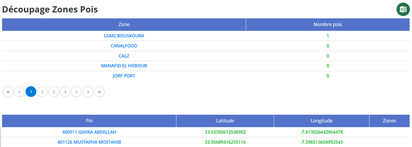
Le rapport de découpage par zones et points d'intérêt (POI) est un outil permettant d’analyser les trajets et les passages des véhicules dans des zones spécifiques. Ce guide détaille chaque colonne du rapport et met en avant sa valeur ajoutée.
Explication des Colonnes
1. Zone
Nom de la zone géographique définie dans le système. Ces zones sont utilisées pour structurer et analyser les passages des véhicules.
2. Nombre POI
Indique le nombre de points d’intérêt (POI) présents dans chaque zone. Un POI peut être une adresse spécifique, un dépôt, une station-service ou tout autre lieu pertinent pour le suivi des trajets.
3. POI
Identifiant et nom du point d’intérêt. Chaque POI est une localisation spécifique permettant d’analyser les arrêts et passages des véhicules.
4. Latitude
Coordonnée GPS indiquant la position exacte du point d’intérêt en termes de latitude.
5. Longitude
Coordonnée GPS indiquant la position exacte du point d’intérêt en termes de longitude.
6. Zones
Indique à quelle zone appartient chaque point d’intérêt. Permet de visualiser la répartition des POI sur différentes zones géographiques.
Valeur Ajoutée du Rapport
-
Analyse des trajets et des arrêts: Permet d’identifier les passages fréquents dans certaines zones et d’optimiser les itinéraires.
-
Optimisation des opérations logistiques: En regroupant les POI dans des zones spécifiques, il devient plus facile de planifier les déplacements.
-
Meilleure gestion des ressources: Permet de mieux répartir les véhicules en fonction des zones d’activité.
-
Suivi précis des zones stratégiques: Aide à identifier les zones les plus fréquentées et celles nécessitant une surveillance accrue.
-
Amélioration de la prise de décision: En disposant d’une vue claire des trajets et des passages par zone, il est plus facile d’optimiser la gestion de flotte.
Ce rapport est un outil puissant pour analyser les trajets et les passages des véhicules par zones spécifiques, facilitant ainsi l’optimisation des ressources et des déplacements.