Module · GPS
Suivi Trajets
Suivi Trajets
Introduction
L’interface Trajet est dédiée à l'affichage et à la gestion des déplacements des véhicules sur une période donnée. Elle permet aux utilisateurs de visualiser de manière précise les trajets effectués par chaque véhicule, avec une représentation claire et intuitive sur la carte.
Visualisation des Trajets
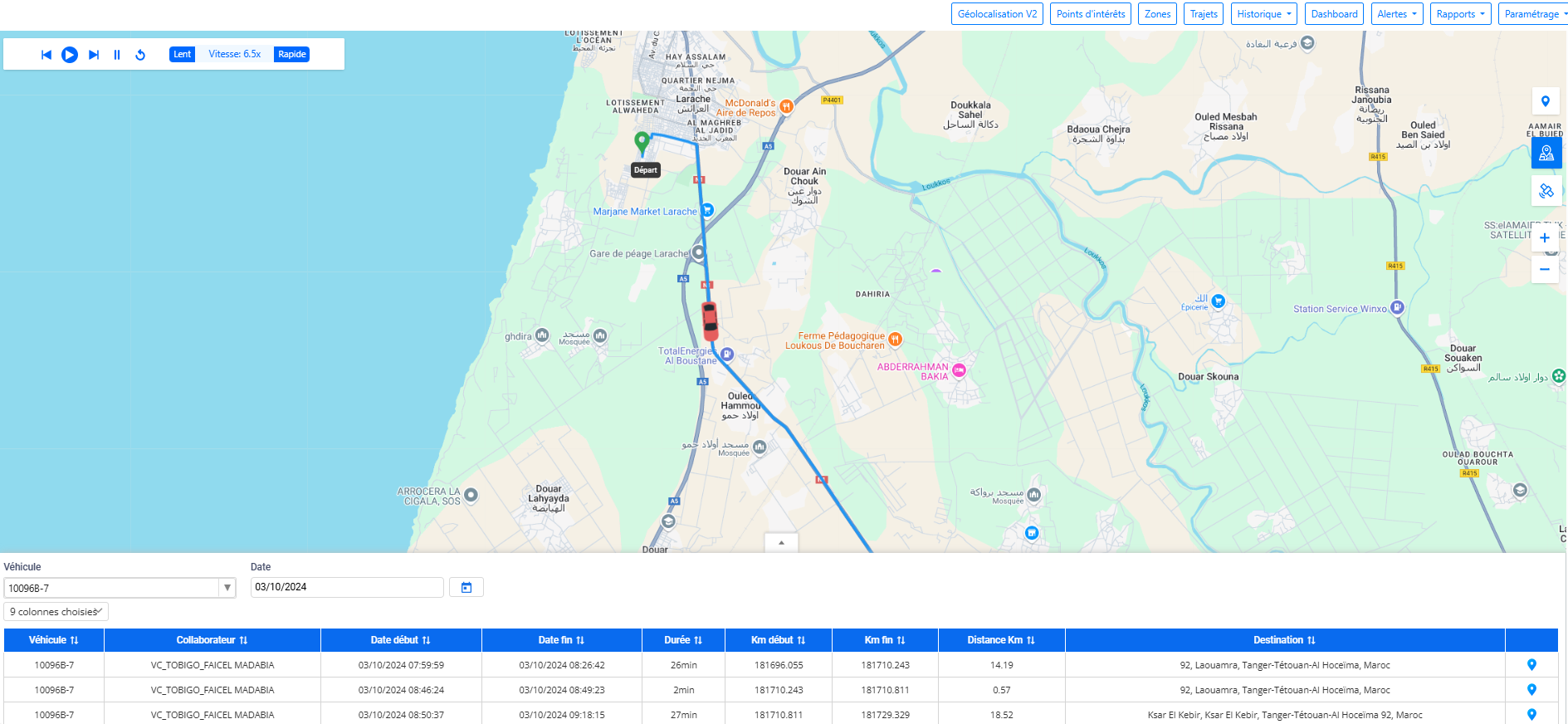
- Affichage du Trajet: En sélectionnant un véhicule et une date spécifique, l'interface affiche l’ensemble des trajets réalisés pendant cette période. Chaque trajet correspond à un parcours que le véhicule a effectué entre chaque démarrage et arrêt.
- Sélection d’un Trajet Spécifique: Pour visualiser un trajet précis, il suffit de cliquer sur l'icône située à droite de chaque enregistrement dans le tableau. Le trajet se génère alors sur la carte, facilitant l'analyse des mouvements du véhicule.
Mode Play avec Contrôle
L’interface offre un mode de lecture dynamique des trajets :
- Mode Play/Pause: Vous pouvez lancer la visualisation du trajet du véhicule sur la carte grâce à un mode lecture interactif, permettant de voir le parcours en temps réel.
- Paramétrage de la Vitesse: Il est possible d’ajuster la vitesse de lecture pour accélérer ou ralentir la visualisation des trajets, ce qui permet d’analyser le déplacement du véhicule selon vos besoins.
- Pause: La lecture peut être mise en pause à tout moment pour observer un point particulier du trajet.
Fonctionnalités de Cartographie
L’interface Trajet intègre plusieurs options de visualisation sur la carte :
- Plein Écran: Vous pouvez basculer la carte en mode plein écran pour une meilleure vue d’ensemble du trajet parcouru.
- Vue Satellite: L’interface permet également de passer en modesatellitepour visualiser les trajets dans un environnement plus réaliste.
- Zoom: Les fonctionnalités de zoom (via les boutons + et - ou en utilisant la molette de la souris) permettent d'agrandir ou de réduire la carte pour examiner les trajets avec plus ou moins de détails.
Tableau de Filtrage
En dessous de la carte, un tableau propose des options de filtrage avancées :
- Sélection du Véhicule et de la Date: En sélectionnant un véhicule et une date, vous pouvez afficher uniquement les trajets correspondant à ces critères.
- Filtrage des Trajets: Le tableau liste les trajets avec des informations claires sur les heures de démarrage et d’arrêt, ainsi que la distance parcourue. Il permet une navigation rapide entre les différents trajets effectués pendant la période sélectionnée.
Visualisation des Trajets
La fonctionnalitéVisualisation des Trajetspermet d'afficher et d'analyser les parcours réalisés par les véhicules sur une période spécifique. Grâce à cette fonctionnalité, vous pouvez suivre les déplacements détaillés de chaque véhicule en sélectionnant une date précise, facilitant ainsi la gestion de la flotte et l’analyse des trajets effectués.
Affichage Dynamique des Trajets
- Visualisation sur la Carte: Les trajets sont affichés sur une carte interactive dès que vous sélectionnez un véhicule et une date. Chaque trajet représente un segment parcouru par le véhicule entre un démarrage et un arrêt, permettant de suivre son parcours étape par étape.
- Trajets Multiples: Si un véhicule a effectué plusieurs trajets pendant la journée, tous ces trajets sont listés et visualisables sur la carte, offrant une vue complète des déplacements.

Sélection d’un Trajet Spécifique
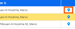
- Icône de Sélection: Pour visualiser un trajet particulier parmi les trajets multiples affichés, il suffit de cliquer sur l’icône située à droite de chaque enregistrement dans le tableau. Ce simple clic génère le tracé du trajet sur la carte, permettant de se concentrer sur un déplacement spécifique.
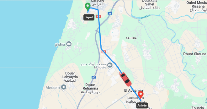
- Affichage Détail par Trajet: En sélectionnant un trajet, vous pouvez voir les points de départ et d’arrivée clairement indiqués sur la carte, ainsi que le chemin parcouru par le véhicule.
Interaction et Contrôle
L'Interaction et le Contrôleau sein de l'interface Trajet de Digiparc offrent une expérience dynamique et flexible pour la visualisation des déplacements des véhicules. Cette fonctionnalité est spécialement conçue pour vous permettre de rejouer les trajets en temps réel, tout en offrant des options de contrôle personnalisées, adaptées à vos besoins d'analyse

Mode Lecture et Pause
- Lecture Dynamique: Le mode lecture permet de rejouer le trajet d’un véhicule, en visualisant ses mouvements sur la carte, comme s’il s'agissait d'un film retraçant son parcours. Cette option est idéale pour voir précisément où un véhicule est allé, à quel moment il a démarré, s’est arrêté ou a changé de direction.
- Pause à tout moment: Vous pouvez à tout moment mettre la lecture en pause. Cela est utile lorsque vous souhaitez analyser un point spécifique du trajet, ou observer un segment critique du déplacement sans que le véhicule ne continue à se déplacer sur la carte.
- Reprise du Trajet: Une fois en pause, la lecture peut être reprise exactement là où elle s'était arrêtée, vous offrant un contrôle total sur l'exploration des trajets.
Paramétrage de la Vitesse
- Contrôle de la Vitesse de Lecture: Vous pouvez ajuster la vitesse de lecture des trajets selon vos besoins. Cette fonctionnalité permet d’accélérer le parcours si vous souhaitez avoir une vue d'ensemble rapide du trajet, ou au contraire de ralentir pour observer les déplacements plus en détail.
- Vitesse Accélérée: En augmentant la vitesse, vous pouvez observer en quelques secondes l'ensemble du trajet réalisé par le véhicule, ce qui est particulièrement utile pour examiner des périodes plus longues ou des trajets complexes.
- Vitesse Ralentit: En ralentissant la vitesse, vous avez la possibilité d'examiner chaque mouvement du véhicule, comme les arrêts, les changements de direction, ou des passages critiques dans certaines zones sensibles.
Avantages du Mode Lecture et du Paramétrage de la Vitesse
- Analyse Précise et Flexible: L’interaction dynamique avec le trajet permet une analyse approfondie, que ce soit pour vérifier la conformité à un itinéraire prévu ou pour observer des comportements spécifiques comme des arrêts imprévus ou des excès de vitesse.
- Gain de Temps: En ajustant la vitesse de lecture, vous pouvez rapidement passer en revue des trajets longs ou, à l’inverse, ralentir l’affichage pour comprendre un point critique. Cela rend l'outil particulièrement utile dans un contexte d’audit ou de gestion de la flotte.
Choix des Colonnes à Afficher dans le Tableau
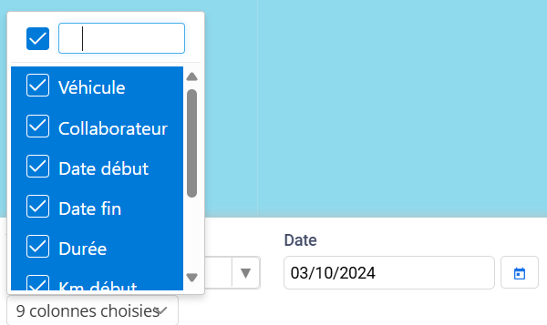
L'interface de Digiparc inclut un tableau dynamique et personnalisable, permettant aux utilisateurs de gérer les informations affichées de manière efficace selon leurs besoins spécifiques. Cette fonctionnalité est conçue pour optimiser la clarté et la pertinence des données présentées.
Affichage et Masquage des Colonnes
- Choix de Colonnes: En haut à gauche du tableau, un menu déroulant vous permet de sélectionner les colonnes que vous souhaitez afficher ou masquer. Chaque colonne est associée à une case à cocher, que vous pouvez activer ou désactiver en fonction des données que vous souhaitez voir à l’écran. Cela permet d’afficher uniquement les informations pertinentes, comme les noms des conducteurs, les immatriculations des véhicules, ou encore les groupes de flotte.
- Optimisation de la Visualisation: Grâce à cette fonctionnalité, vous pouvez alléger le tableau pour ne conserver que les données essentielles à l'analyse en cours. Par exemple, vous pouvez décider de n’afficher que la colonne de la flotte et de masquer les informations moins nécessaires comme le kilométrage ou la vitesse, pour se concentrer sur la gestion des véhicules appartenant à une catégorie spécifique.
Tri et de Recherche
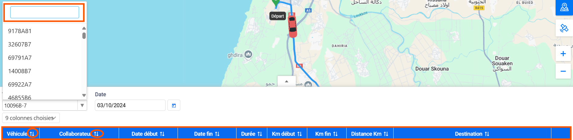
- Recherche Intuitive: Le tableau intègre une barre de recherche puissante qui vous permet de trouver rapidement des informations en tapant le nom du collaborateur, le numéro de la flotte, l’immatriculation d’un véhicule ou tout autre attribut. Cela accélère la navigation, surtout lorsque vous gérez un grand nombre de véhicules et de collaborateurs.
- Tri Automatisé: Chaque colonne peut être triée de manière ascendante ou descendante. Que vous souhaitiez classer les véhicules par ordre alphabétique, par la dernière position enregistrée ou par vitesse instantanée, cette fonctionnalité permet de structurer les informations rapidement pour une meilleure lisibilité.
Zoom, Navigation, et Changement de Mode Satellite
Ces fonctionnalités offrent une interaction fluide avec la carte, permettant aux utilisateurs d'ajuster l'affichage et de personnaliser la manière dont les trajets sont visualisés.
Fonctionnalité Zoom
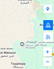
- Zoom Avant et Arrière: Grâce aux boutons de zoom (+ et -) intégrés à l'interface, vous pouvez agrandir ou réduire la carte selon vos besoins. En zoomant, vous pouvez visualiser avec précision des zones spécifiques, comme des rues, des intersections ou des points d'intérêt traversés par les véhicules. À l’inverse, le zoom arrière permet d’avoir une vue d’ensemble plus large sur l’ensemble du trajet ou sur plusieurs trajets simultanément.
- Navigation avec la Molette de la Souris: Pour plus de commodité, le zoom peut également être contrôlé à l’aide de la molette de la souris, offrant un moyen rapide et intuitif d’ajuster la vue en fonction de la situation.
- Zoom Dynamique sur un Trajet: Lorsque vous sélectionnez un trajet spécifique, le zoom s’adapte automatiquement pour centrer la carte sur l’itinéraire, facilitant ainsi l’analyse du parcours sans avoir à ajuster manuellement la vue.
Fonctionnalité Navigation
- Déplacement de la Carte: Vous pouvez naviguer facilement sur la carte en cliquant et en glissant pour explorer différentes parties de l’écran. Cela permet de parcourir de longues distances sans perdre de vue les trajets ou les zones d’intérêt. Cette fonctionnalité est particulièrement utile lorsque vous souhaitez observer des segments éloignés d’un même trajet ou naviguer entre plusieurs véhicules actifs sur la carte.
- Navigation Précise entre les Points Clés: La fonctionnalité de navigation vous permet de passer aisément d’une zone à une autre, en vous concentrant sur des lieux spécifiques tels que des points d'arrêt ou des points de départ, pour obtenir une analyse plus fine des déplacements des véhicules.
Fonctionnalité Changement de Mode Satellite
- Affichage en Mode Satellite: L’interface permet de basculer en un clic entre deux modes d’affichage : la vue classique (plan) et la vue satellite. Le mode satellite propose une représentation réaliste des trajets, avec des images détaillées des zones géographiques traversées par les véhicules. Ce mode est particulièrement utile pour identifier des caractéristiques géographiques spécifiques, comme des bâtiments, des routes non marquées sur les cartes traditionnelles ou des terrains difficiles d’accès.
- Affichage Classique (Plan): En alternant entre les deux modes, les utilisateurs peuvent passer du mode satellite au mode plan, qui présente une vue plus simplifiée et schématique de la carte. Ce mode est souvent utilisé pour analyser les trajets avec moins de détails visuels, facilitant une vue d’ensemble.